Catalina Island

General Info:

     Catalina Island is located approx. 28 nautical miles SW of Los Angeles harbor.

It is 21 miles long and 8 miles at it's widest points. There is a small town located on the east end called Avalon, which is a popular tourist attraction for Southern California. The island is also popular for fishing, diving and other recreational activities.


Fishing Info:

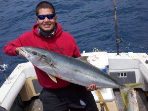
    There are a variety of saltwater gamefish which can be found here year round including : Calico Bass, White Sea Bass, Halibut, Bonito, and homeguard Yellowtail. Seasonally, migrating Yellowtail, Barracuda, and Dorado may also be taken from the Island. Also, Yellowfin tuna and Marlin are taken some years just a few miles off shore. Spring and Summer are the best times to fish here although some good bites on the White Sea Bass and homeguard Yellowtail are known to happen during the winter months when the squid start to show. Be sure to check the DFW web site for regulations and closures before heading out.


  • GPS Reference Points (HRS.MIN.SEC)
  • Frontside
  • West End : 33.28.45 / 118.36.24
  • Starlight Beach : 33.28.39 / 118.36.04
  • Arrow Point : 33.28.42 / 118.32.19 - No lobster fishing east of this point.
  • Indian Rock : 33.28.05 / 118.31.33
  • Eagle Reef : 33.28.01 / 118.30.40
  • Lion Head : 33.27.11 / 118.30.05 - No lobster fishing west of this point.
  • Isthmus Harbor : 33.26.36 / 118.29.43
  • Isthmus Reef : 33.26.55 / 118.29.21
  • Blue Cavern MPA1 : 33.26.38 / 118.29.20 - No Fishing east of this line.
  • Blue Cavern MPA2 : 33.25.58 / 118.27.00 - No Fishing west of this line.
  • Red Bluffs : 33.25.45 / 118.25.37
  • Gibralter Reef : 33.25.32 / 118.24.53
  • Long Point SMR1 : 33.25.06 / 118.24.00 - No Fishing east of this line.
  • Long Point SMR2 : 33.24.26 / 118.21.59 - No Fishing west of this line.
  • Long Point : 33.24.22 / 118.21.53
  • K-20 : 33.23.18 / 118.21.51
  • Frog Rock : 33.21.40 / 118.20.07
  • Avalon Harbor : 33.20.45 / 118.19.18
  • Rock Quarry : 33.18.52 / 118.17.55
  • Seal Rocks : 33.18.24 / 118.18.23
  • East End : 33.18.03 / 118.19.06
  • Backside
  • West End Humps : 33.27.55 / 118.37.04 - Rockfish
  • West Cove : 33.27.58 / 118.35.42
  • Iron Bound Cove : 33.26.48 / 118.34.30
  • Whale Rock : 33.25.59 / 118.33.16
  • Cat Harbor : 33.25.42 / 118.30.31 - MPA, No Fishing.
  • Little Harbor : 33.23.10 / 118.28.29
  • Sentinnel Rock : 33.22.21 / 118.29.18
  • Farnsworth MPA 1 : 33.21.00 / 118.29.05 - No fishing east of this line.
  • Farnsworth Bank : 33.20.35 / 118.31.05 - MPA, No Fishing.
  • China Point : 33.19.56 / 118.28.21
  • Farnsworth MPA 2 : 33.19.33 / 118.27.55 - No fishing west of this line.
  • Freddies Beach : 33.19.10 / 118.26.38
  • Salta Verde Point : 33.19.03 / 118.26.29
  • Orange Cliffs : 33.18.52 / 118.25.18
  • Silver Canyon : 33.19.07 / 118.23.23
  • Palisades : 33.19.00 / 118.22.34
  • Vees : 33.18.36 / 118.21.10
  • Church Rock : 33.17.48 / 118.19.38


Comments and Tips:

    Although it is generally calm around this island (especially the front side), boaters should be aware that rough conditions can occur in-between the island and mainland. Smaller vessels less than 20ft. are not recommended for crossing the channel unless you are an experienced captain and know the ocean conditions well.


    If you know something about this area or have some photos that you'd like to share, please E-mail and I'll post it here!

» Photos

  • FNN member "San Felipe Bob" took his family fishing at Catalina Island and caught some nice yellowtail!>>>Report

  • FNN member "BlakeB" with a 40 pound yellowtail caught recently at Catalina Island. >>>Report


  • » Our Sponsors


    Newport Landing Sportfishing


    Davey's Locker Sportfishing


    Carver Covers


    The Fishing Syndicate