Coronados Islands

General Info:

     The Coronados Islands are located approx. 13 nautical miles S of San Diego Bay at a 170 degree SE

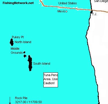
(magnetic) heading. The Islands are in Mexican waters so be sure to have proper fishing license and documentation before heading here.


  • GPS Reference Points
  • North Coronado Island : 33.27.00 / 117.18.00
  • Middle Coronado Island : 33.25.50 / 117.15.50
  • South Coronado Island : 33.23.00 / 117.14.00
  • South Kelp : 32.21.00 / 117.12.50
  • Rockpile : 32.17.50 / 117.10.50

Fishing Info:

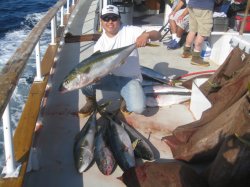
    There are a variety of gamefish which can be found here year round including : calico bass, sand bass, white sea bass, halibut, rockfish and lingcod. Seasonally, migrating yellowtail, barracuda, and sometimes other pelagics such as dorado, bluefin, yellowfin, and even albacore may sometimes be taken from the waters surrounding these islands.

Coronados Islands Map

Most of the 3/4 day fishing boats from San Diego venture here year-round. Mexican fishing permits are usually included in the fare.

  • Read and Post Coronados Islands Fishing Reports Here

  • Comments and Tips:

        If you know something about this area or have some photos that you'd like to share, please E-mail and I'll post it here!


  • FNN member Liteliner with a limit of Coronados yellowtail caught 3/2/2010.

  • » April 2024

    S M T W T F S
    31 1 2 3 4 5 6
    7 8 9 10 11 12 13
    14 15 16 17 18 19 20
    21 22 23 24 25 26 27
    28 29 30 1 2 3 4

    » Our Sponsors


    Newport Landing Sportfishing


    Davey's Locker Sportfishing


    Carver Covers


    The Fishing Syndicate